Professional Coordinate Management Made Simple
Collect, convert, and share GPS coordinates in any coordinate system. Work seamlessly with your team across mobile and web, online or offline.
Everything You Need for Coordinate Work
Any Coordinate System Supported
Work with GPS, UTM, or country-specific coordinate systems from over 20 countries. Convert coordinates between systems instantly and collect data in the format you need.
Real-Time Team Collaboration
Share coordinate layers with teammates and see updates instantly. Work together on the same project with cloud sync across mobile and web platforms.
Work Offline, Sync Automatically
Collect coordinates in remote areas without internet connection. Your data syncs automatically when you're back online, so you never lose your work.
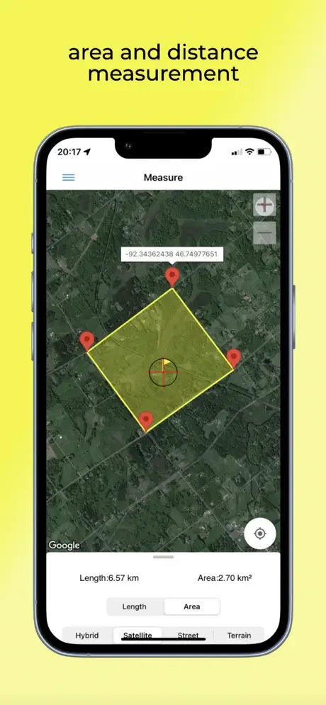
Precise Measurement Tools
Calculate areas, distances, and elevations with professional accuracy. Export your measurements to KML or Excel files for easy sharing and reporting.
About
Coordinator App
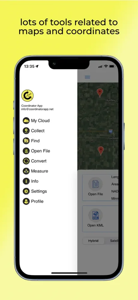
Core Features
- Collect coordinate data from land in any coordinate system you choose, from predefined systems
- Collect GPS coordinates
- Use the app as a GPS tracker
- View the coordinate data on the map
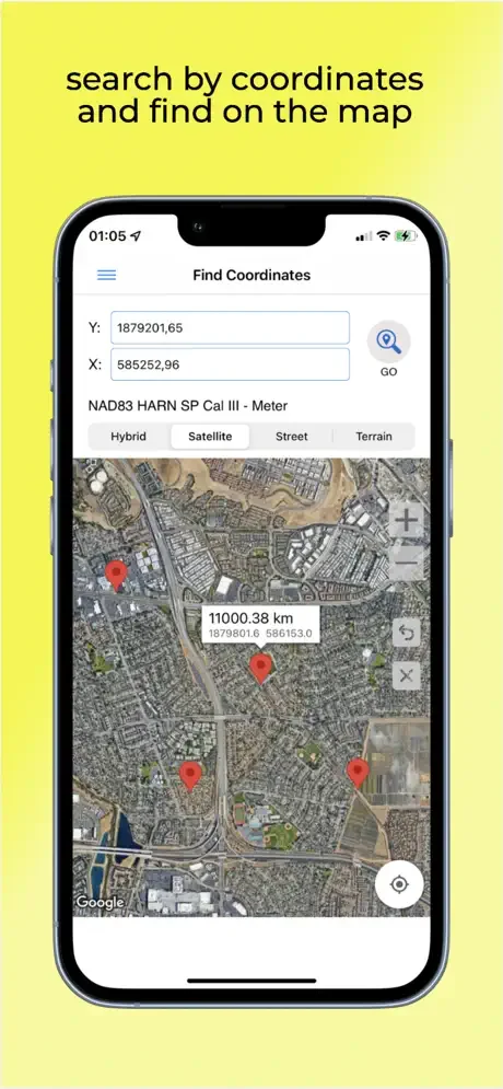
- Search by longitude/latitude
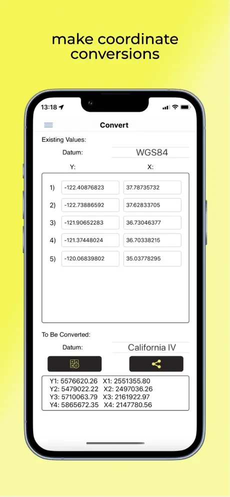
- Convert an existing coordinate into another coordinate system
- Display circumference and area measurements for some coordinates by opening the file created earlier
- Measure distances and areas for coordinates marked on the map manually
- Display a KML file on the map
The coordinator app contains several useful tools for people interested in coordinates, maps, and geographic information systems (GIS).
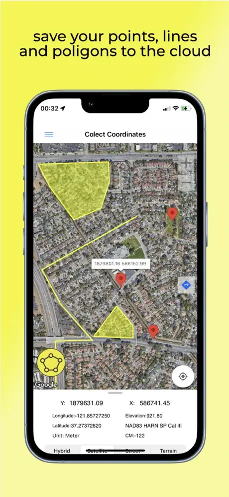
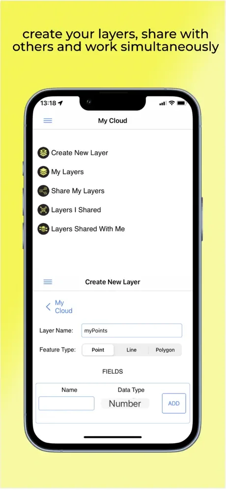
Cloud Database and Advanced Features
The coordinator offers Cloud Database Functions (creating points, lines & polygons; sharing your layers with teammates; working simultaneously with teammates; working offline and synchronizing; etc.), exporting to KML & Excel files, retrieving the elevation value of points, and so on. You can create your layers and share those layers with your teammates. You can instantly see the data created by other friends on the map.
In addition to longitude/latitude, subscribers can find the altitude of a point on the map. Subscribers can use the Coordinator Web app. So you can use the cloud database features of the Coordinator app on your computer's web page and monitor the data instantly. You can view/track and edit cloud database data on the web page. In this way, you can instantly monitor data movements in the mobile app in the field and in the web browser on your computer.
Supported Coordinate Systems by Country
The coordinate systems of the countries where the app is most downloaded are added to the app.
Current list of countries and their coordinate systems defined in this app:
- World - GPS(WGS 84)
- World - WGS 84 - 6 UTM
- United States - "NAD 1983 HARN State Plane Coordinate Systems(meters & feet)" and "Military Grid Reference System (MGRS)"
- Algeria - "Nord Sahara 1959 / UTM 6 "
- Azerbaijan - "Pulkovo 1942 / Gauss-Kruger 3 " and "Pulkovo 1942 / CS63"
- Bulgaria - "Pulkovo 1942(58) GK 6 "
- Germany - "DHDN/3 GK" and "ETRS89 UTM 6"
- India - "Kalianpur 1975 / India" and "Kalianpur 1975 / UTM 6"
- Indonesia - "Indonesia 1974 UTM 6" and "DGN 1995 Indonesia TM3"
- Iran - "ED50(ED77) / UTM 6"
- Iraq - "Nahrwan 1967 / UTM 6", "ED50 / Iraq National Grid", and "Karbala 1979 / UTM 6"
- Israel - "Palestine 1923/Palest. Grid" and "Palestine 1923/Israeli CS Grid" and "Israel 1993/Israeli TM Grid"
- Lebanon - "Deir ez Zor / Levant Ster." and "Deir ez Zor / Syria Lambert."
- Mauritania - "Mauritania 1999 / UTM 6"
- Morocco - "Merchich / Nord Maroc" and "Merchich / Sud Maroc"
- Netherlands - "Amersfoort / RD New" and "Amersfoort / RD Old"
- Palestine - "Palestine 1923/Palest. Grid" and "Palestine 1923/Israeli CS Grid" and "Israel 1993/Israeli TM Grid"
- Philippines - "Luzon 1911 / Philippines" and "PRS92 / Philippines"
- Romania - "Dealul Piscului 1930 / Stereo 33" and "Pulkovo 1942(58) / Stereo 70"
- Russia - "Pulkovo 1942 / Gauss-Kruger 3"
- Saudi Arabia - "Ain el Abd / UTM 6" and "Ain el Abd / Aramco Lambert."
- Syria - "Deir ez Zor / Levant Ster." and "Deir ez Zor / Syria Lambert."
- Turkey - "ITRF 96 - 3" and "ED 50 - 3" and "ITRF 96 - 6" and "ED 50 - 6"
- United Arab Emirates - "Nahrwan 1967 / UTM"
Legal
See the App in Action